
Use this formatted version so it looks cleaner, more natural, and less AI-generated inside your article.
Quick Summary
- Guyana has 165+ named rivers, with four major waterways dominating the landscape: the Essequibo, Demerara, Berbice, and Courantyne.
- The Essequibo River is the longest, stretching 1,014 km and draining more than half of Guyana’s land area.
- Most of Guyana’s rivers flow northward before emptying into the Atlantic Ocean.
- Kaieteur Falls, located on the Potaro River, plunges 226 metres — more than four times the height of Niagara Falls.
- In much of Guyana’s interior, rivers function like highways, providing transport routes, supporting agriculture, and connecting remote communities.
- These waterways are also vital biodiversity corridors, home to hundreds of fish species and unique rainforest ecosystems.
- The biggest modern threat to Guyana’s river health is mercury contamination caused by artisanal gold mining in interior river basins.
Spend enough time looking at a map of Guyana and something starts to sink in. The country is not just surrounded by rivers — it is stitched together by them. Every major settlement, every agricultural belt, every historic event seems to trace back to one waterway or another.
I did not fully appreciate that until I started cross-referencing old colonial maps with current satellite data for this piece. What struck me almost immediately was how little had changed in terms of basic geography. The rivers the Dutch navigated in the 1600s are still the same rivers driving communities and commerce today.
This guide covers everything worth knowing about the rivers of Guyana — from the big four to the key tributaries, the historical weight they carry, the economic role they play, and the environmental pressures they face in 2026. Whether you are a student, a traveller, or just deeply curious — let’s get into it.
Table of Contents
- 1. How Many Rivers Does Guyana Have?
- 2. The 4 Main Rivers — What You Need to Know
- 3. Essequibo River — The River That Defines the Country
- 4. Demerara River — Don’t Underestimate This One
- 5. Berbice River — Where History and Agriculture Meet
- 6. Courantyne River — Guyana’s Eastern Edge
- 7. Tributaries That Deserve More Attention
- 8. Rivers of Guyana — Comparison Table
- 9. Why Guyana’s Rivers Matter More Than You Think
- 10. What’s Threatening These Rivers in 2026?
- 11. Frequently Asked Questions (FAQs)
- 12. Final Thoughts
1. How Many Rivers Does Guyana Have?
Short answer: a lot. Official answer: complicated.
The Guyana Lands and Surveys Commission lists approximately 165 named rivers. That number climbs past 300 once you include minor creeks, seasonal channels, and unnamed distributaries. I came across conflicting figures while researching this — some sources say 165, others go higher — so I have stuck with the government body’s official count throughout.
What matters more than the total number is the structure. Guyana’s rivers are not randomly scattered. They follow a clear logic: most rise in the southern and western highlands — the Pakaraima Mountains, the Acarai range, the ancient Guiana Shield — and push northward toward the Atlantic. Four of them do this independently. The rest feed into the largest of the four.
That largest river is the Essequibo. It drains over half the country on its own. The others — Demerara, Berbice, and Courantyne — drain their own coastal and highland corridors. Together, these four are the backbone of the country’s entire hydrological system.
2. The 4 Main Rivers of Guyana — What You Need to Know
Here is the quick version before the deep dives:
- Essequibo (1,014 km) — Longest. Largest drainage basin. Biodiversity capital of Guyana’s rivers. Drains over half the country.
- Courantyne (677 km) — Eastern international border with Suriname. Flows from the Brazil-Suriname highlands to the Atlantic.
- Berbice (595 km) — Rice and sugarcane country. Scene of the 1763 slave rebellion that made Cuffy a national hero.
- Demerara (346 km) — Shortest of the four. Runs through the capital Georgetown. Arguably the most economically active waterway in the country.
Each one has its own character, its own history, its own economic role. None of them are interchangeable.
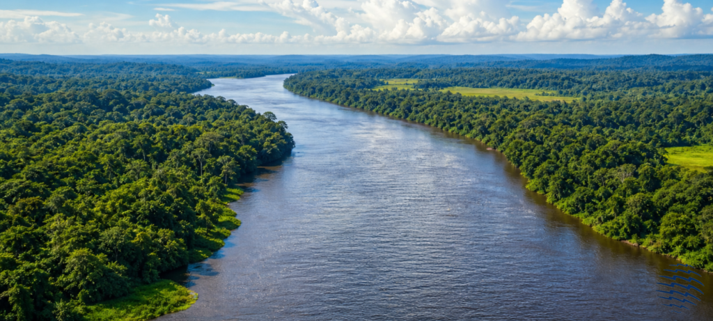
3. Essequibo River — The River That Defines the Country
If there is one river that completely shapes Guyana, it is the Essequibo. Calling it ‘important’ undersells it. This river is, in many ways, the reason large parts of Guyana’s interior are accessible at all.
It rises in the Acarai Mountains near the Brazilian border and travels 1,014 kilometres northward before reaching the Atlantic — entering the ocean about 21 kilometres west of Georgetown through a 20-kilometre-wide estuary dotted with several inhabited islands: Leguan, Wakenaam, Hogg Island. The estuary alone is bigger than most rivers I had seen on regional maps before researching Guyana specifically.
The drainage basin — 156,828 square kilometres — covers more than half of the country’s total land area. By regional comparison, the Essequibo sits between the Orinoco and the Amazon in terms of scale. It is not a small river. It just does not get the international attention those two do.
What surprised me most, honestly, was the biodiversity data. Scientists have documented over 300 fish species in the Essequibo basin — including roughly 60 species found nowhere else on Earth. Those are not small numbers. Surveys of the upper Mazaruni tributary alone found between 36 and 39 species, with up to 25% still undescribed in recent literature. The river hides things science has not fully catalogued yet.
Beyond fish: the banks support giant river otters (one of the world’s most endangered mustelids), black caimans, tapirs, anacondas, and harpy eagles — the largest eagle in the Western Hemisphere. The Essequibo is not just a transport route. It is a functioning wildlife corridor through the heart of an intact rainforest.
Historically, the lower Essequibo was the starting point of Dutch colonisation. The first European settlement in Guyana was built along its banks in 1615. Today, for communities in the deep interior — many of them Amerindian villages with no road access — the Essequibo and its tributaries are still the only way in or out.
| => Pro Tip If you are planning a river expedition on the Essequibo, note that waterfalls and rapids limit navigation beyond the lower stretches. Most guided tours operate from Bartica — a supply town at the confluence of the Mazaruni and Essequibo — and cover the lower basin’s islands and wildlife corridors. |
4. Demerara River – Don’t Underestimate This One
I assumed, going into this research, that the Essequibo would dominate every conversation about Guyana’s waterways. Geographically, it does. But the more I looked at how the country functions day to day, the more the Demerara kept coming up.
At just 346 kilometres, it is the shortest of the four main rivers. But it flows directly through Georgetown. That changes its significance entirely.
The Demerara Harbour Bridge — a floating pontoon structure just below Georgetown — connects the city’s east and west banks and is one of the longest floating bridges in the world. Large cargo vessels navigate the lower river regularly to service Georgetown’s port. The river’s estuary is Guyana’s main maritime commercial gateway.
Head upstream and the character changes. You reach Linden — Guyana’s second-largest city — which developed around bauxite extraction. Bauxite deposits near the river are mined and shipped downstream for export. That single commodity defined the entire Demerara economic corridor for decades and still shapes it today.
The water is tan and heavy with silt. When the Demerara meets the Atlantic, it creates a visible sediment plume that extends far into the ocean — you can see it from the air. Not glamorous. But informative.
The communities between Georgetown and Linden — small farms, fishing settlements, market gardens along the river banks — represent a cross-section of ordinary Guyanese life. For more on this region, our guide to Guyana Region 4 Demerara-Mahaica, Where the Country Feels Most Alive covers it in detail.
5. Berbice River – Where History and Agriculture Meet
The Berbice River runs roughly 595 kilometres through lowland rainforest and agricultural land before reaching the Atlantic at New Amsterdam — Guyana’s third-largest town. Where the Essequibo feels wild and the Demerara feels commercial, the Berbice feels inhabited. Productive. Old.
This is rice country. And sugarcane country. Dutch colonial engineers built an intricate canal network along the Berbice’s lower banks that is — and this is worth pausing on — still in operational use today. Canals built centuries ago are still diverting river water into paddies. That level of infrastructure longevity is unusual.
And then there is the history. The Berbice Slave Rebellion of 1763 — one of the largest slave uprisings in Caribbean history — started on the plantations along this river. Led by Cuffy (Kofi), now recognised as Guyana’s first national hero, roughly 2,500 enslaved people took control of much of the colony for nearly a year. When you travel the Berbice today, that history is not abstract. It happened on those specific banks.
For wildlife, the Berbice’s tributary — the Canje Creek — is particularly worth knowing. It is prime habitat for the Hoatzin, Guyana’s national bird. Birdwatchers who visit tend to come back with lists that surprise them.
6. Courantyne River – Guyana’s Eastern Edge
The Courantyne River — spelled Corentyne in Guyana, Corantijn in Suriname — runs about 677 kilometres and forms the entire eastern border between the two countries. It rises in the Tumuk-Humak Mountains near the Brazil-Suriname border and flows north to the Atlantic.
The lower river is shared. The mouth — slightly confusing at first — involves ongoing diplomatic nuance about navigation rights and resource jurisdiction. The towns of Skeldon (Guyana) and Nieuw Nickerie (Suriname) face each other across the water: different countries, often the same extended families on both sides.
Upper reaches are difficult to navigate due to rapids and falls. That inaccessibility has kept much of the upper Courantyne basin relatively undisturbed. Timber resources and some gold deposits exist in the area, but large-scale extraction has been limited compared to other river corridors.
7. Tributaries That Deserve More Attention
Potaro River and Kaieteur Falls
The Potaro is 225 kilometres long. It is a tributary of the Essequibo. And it carries something extraordinary: Kaieteur Falls — a single-drop waterfall with a vertical descent of 226 metres. More than four times the height of Niagara Falls. It sits inside Kaieteur National Park, roughly 226 kilometres from Georgetown, with almost no tourist infrastructure around it.
The falls were only formally documented by Western science in 1870. Indigenous Patamona people had known about them for considerably longer. If you are planning a visit, our guide on Tours to Kaieteur Falls Guyana (2026): What It’s Really Like to Go is worth reading before you book anything.
| => Pro Tip Most visitors reach Kaieteur Falls by small charter plane from Georgetown (around 45 minutes each way). There is no road access. Day trips are possible, but staying overnight — if you can arrange it — gives you the falls at dawn, virtually alone. |
Mazaruni River — Gold and Diamonds
About 320 kilometres long, joining the Essequibo near Bartica. The Mazaruni corridor has been mined for gold and diamonds since the colonial era. Bartica grew up entirely as a supply hub for interior mining operations. Artisanal small-scale mining still continues along most of the river — not exactly glamorous work, economically significant nonetheless.
The Mazaruni is also where mercury contamination is most documented. A 2024 environmental monitoring report by the Guyana Environmental Protection Agency flagged elevated mercury levels in fish samples from the middle and lower Mazaruni — a direct consequence of small-scale gold processing using mercury amalgamation. The data is concerning, particularly for riverside communities that depend on fish protein.
Rupununi River — The Amazon Handshake
This one I found genuinely fascinating when I first came across it. The Rupununi flows through Guyana’s largest savanna region in the southwest. During the wet season, floodwaters create a temporary hydrological connection between the Rupununi watershed and the Takutu River — which feeds into the Amazon basin in Brazil.
That seasonal link, which has existed for millennia, explains something biogeographically strange: certain fish species found in the Amazon also appear in the Essequibo basin. Two separate river systems, connected by an ancient annual flood. It is the kind of detail that makes fluvial geography genuinely interesting.
Cuyuni River — The Political One
Rising in Venezuela and flowing east into Guyana, the Cuyuni runs about 780 kilometres total before joining the Mazaruni. Part of its basin falls within the Essequibo region that Venezuela has historically claimed as Venezuelan territory — a dispute that remains active in 2026, with international arbitration proceedings ongoing. The river itself is unaware of the politics, of course. But travellers in the northwest should be.
8. Rivers of Guyana — Comparison Table
Here is a reference table for the main rivers and key tributaries:
| River | Length | Basin (km²) | Outflow | Notable Feature |
| Essequibo | 1,014 km | 156,828 | Atlantic Ocean | 300+ fish species; 60 endemic |
| Courantyne | 677 km | Shared/Suriname | Atlantic Ocean | International border river |
| Berbice | 595 km | Independent | Atlantic / New Amsterdam | Colonial canal irrigation network |
| Demerara | 346 km | Independent | Atlantic / Georgetown | Floating pontoon harbour bridge |
| Rupununi | ~600 km | Essequibo trib. | Essequibo River | Seasonal Amazon connection |
| Mazaruni | ~320 km | Essequibo trib. | Essequibo River | Gold & diamond mining corridor |
| Potaro | 225 km | Essequibo trib. | Essequibo River | Kaieteur Falls (226 m drop) |
| Cuyuni | ~780 km | Essequibo trib. | Essequibo River | Partly in Venezuela |
9. Why Guyana’s Rivers Matter More Than You Think
Most geography guides list the rivers, give you the lengths, and move on. What they skip is why any of it actually matters. Here is that part.
Transport without roads. Large sections of Guyana’s interior have no road infrastructure at all. Not poor roads. No roads. The Essequibo and its tributaries, the upper Berbice, the Rupununi — these are the transport network for dozens of Amerindian communities. River access is the difference between a community being reachable and unreachable.
Agriculture that still works. The canal systems built along the Berbice and Demerara during the colonial era — designed to irrigate rice paddies and sugarcane fields — are still operational. Guyana is one of the Caribbean region’s major rice exporters, and that industry runs on river water managed through infrastructure that is centuries old.
Biodiversity that rivals anywhere. Guyana consistently ranks among the top five most biodiverse countries in South America per square kilometre. That ranking depends directly on healthy riparian ecosystems — the forest-river interfaces where most species concentrate. The Essequibo basin alone has more fish species than the entire continental United States.
Economic extraction. Gold and diamonds — significant contributors to Guyana’s GDP — come almost exclusively from river valleys. The Mazaruni, Cuyuni, Potaro, and upper Essequibo basins have been mined for centuries. The rivers make extraction possible. They also absorb the environmental cost of it.
Cultural and national identity. The rivers appear in the national anthem: “dear land of Guyana, of rivers and plains.” That is not just poetic language. It reflects something real about how Guyanese people relate to their geography. The Essequibo controversy with Venezuela is a territorial dispute, but it is also felt as something more personal than a boundary line.
10. What’s Threatening Guyana’s Rivers in 2026?
Guyana’s rivers are in comparatively good shape — better than equivalent systems in Brazil, Colombia, or Peru. But ‘better than’ is not the same as ‘fine.’ Several pressures are worth tracking:
- Mercury from artisanal gold mining: This is the most documented and most serious current threat. Mercury used in gold amalgamation enters river systems and bioaccumulates through the food chain. A 2024 EPA monitoring report flagged elevated levels in Mazaruni fish samples. Communities eating fish from affected areas face genuine health risks.
- Deforestation along banks: Selective logging and agricultural expansion remove the riparian vegetation that stabilises river banks, filters runoff, and regulates sediment loads. More silt means degraded water quality and damaged aquatic habitats.
- Climate pattern shifts: Wet and dry seasons are becoming less predictable. Agricultural communities along the Berbice and Demerara have timed their planting cycles to seasonal river rhythms for generations. When those rhythms shift, farming calendars get disrupted.
- Oil development pressure: Guyana’s offshore oil sector has transformed the national economy since ExxonMobil’s Stabroek Block discoveries. As of 2026, Guyana is producing over 600,000 barrels per day. The concern is not the offshore extraction itself, but whether the economic acceleration strengthens or weakens environmental governance capacity onshore — particularly for river corridor protection.
None of this is irreversible. But the window for proactive management is narrower in 2026 than it was a decade ago.
11. Frequently Asked Questions (FAQs)
| How many rivers are in Guyana? |
| The Guyana Lands and Surveys Commission lists approximately 165 named rivers. Including minor creeks and seasonal waterways, estimates exceed 300. The four primary rivers — Essequibo, Demerara, Berbice, and Courantyne — all flow northward into the Atlantic Ocean. |
| What are the 3 main rivers in Guyana? |
| Narrowing to three: the Essequibo (longest, drains over half the country), the Demerara (commercially most important, flows through Georgetown), and the Berbice (agricultural heartland with major historical significance). The Courantyne rounds out the traditional big four. |
| What is the largest river in Guyana? |
| The Essequibo River, at 1,014 kilometres, with a drainage basin of 156,828 square kilometres. It is the largest river in Guyana and one of the most significant in northern South America, sitting between the Orinoco and Amazon in regional scale. |
| What does ‘Dear Land of Guyana of rivers and plains’ mean? |
| This is a line from Guyana’s national anthem, reflecting the country’s deep geographical and cultural identity around its river systems and the Rupununi savanna plains. Rivers are not just infrastructure in Guyana — they are central to how Guyanese people understand their homeland. |
| Which river forms the border between Guyana and Suriname? |
| The Courantyne River (also spelled Corentyne or Corantijn in Suriname). It runs approximately 677 kilometres and marks the entire eastern boundary between both countries before reaching the Atlantic Ocean. |
| What are the major tributaries of the Essequibo River? |
| The main tributaries feeding into the Essequibo are the Mazaruni, Cuyuni, Potaro, Rupununi, Siparuni, and Konawaruk rivers. The Potaro is the most famous — it carries the outflow from Kaieteur Falls, one of the world’s most powerful single-drop waterfalls. |
12. Final Thoughts
I started this piece thinking it would be a geography overview. The rivers, the lengths, the drainage basins. Done.
It became something more interesting. The rivers of Guyana are not passive features on a map. They are active forces that shaped the country’s colonial history, underpin its agricultural economy, anchor its biodiversity, connect its most isolated communities, and sit at the centre of its ongoing environmental and territorial challenges.
What makes Guyana unusual — genuinely unusual by South American standards — is that most of this is still intact. The fish are still there. The forest is still there. The communities that depend on the rivers are still functioning the way they have for generations.
That is not something to take for granted. And in 2026, with offshore oil revenues flowing in and development pressure rising, it is worth paying attention to what happens next.
If this guide sparked your curiosity about Guyana’s geography and culture, explore the rest of our content. There is a lot more to this corner of South America than most guides give it credit for.